 Pinamungajan is a coastal town on the mid-western part of Cebu facing the island of Negros. The terrain of the municipality is mountainous and believed to be rich in minerals such as silica, material for cement production, highly energized source of water; ideal for natural ionic drink and many more.
Originally, when the town was still a village it was called KABUNGAHAN, derived from betel nut trees which thrived luxuriantly in the locality.
When the Spanish friars established the Catholic Church in KABUNGAHAN in 1850, they renamed the place “PINAMUNGAJAN” or ABUNDANT “BUNGA”. Another origin of the name PINAMUNGAJAN rooted from the word PAMU-OHAN which means a worker's share in the agricultural harvest.
Pinamungajan is a second class municipality and has a population of 62,000 people in 2007. It is 64 kilometers away from Cebu City via Toledo and 74 kms. via Carcar. Here you will see different natural and heritage sights.
Natural Sights
 Campalabo Islet
One of the thousand islands of the country that is declared a Marine Sanctuary with a rich variety of sea flora and fauna.
 Gok-ong Sea Rock
This rock formation juts out of the sea and provides the residents a picnic ground during high tides.
 Guanon - Bantayan sa Hari
A natural watch tower, the Bantayan sa Hari(The King's Watch Tower) at Barangay Tutay was used by Pinamungajanons against the Moro pirates during the Spanish time.
 Corn Hills
A cluster of 14 hills at Barangay Tupas that somewhat replicates Bohol’s Chocolate Hills. The hills are used by the town's folk for their corn plantation.
 Caves of Lamac
One of the 108 caves of Lamac that became the site of the 2004 National Mounting Climbing Congress spearheaded by the Philippine Speleological Society. These caves also served as evacuation centers during the World War II.
Heritage Sights
 Municipal Hall
The seat of the municipal government of Pinamungajan that was built in 1917. This building had undergone face lifting but the old structure remains.
 Municipal Kiosk
Located right in front of the Municipal Hall. The kiosk provides a breathtaking view of the sea from the veranda. A place for short walks, strolls , fun and recollections for young and old it also contributes to the beautiful panorama during sunset.
 Sea Wall
A wave-shaped wall built by the Americans that serves a protection from the raging seas during turbulent storms and high tides. This perfect place fronting the Tañon Strait provides a magnificent panorama of the beautiful sunset in Pinamungajan.

Old House
An old traditional house with a high floor built in 1950 owned by Miss Corazon Piala.
 Sta. Monica Parish Church
This church was built in 1891 and one can still see the coral stones that were collected by the town’s people who lived during the Spanish time. It houses the miraculous image of Santa Monica and four (4) church bells with Spanish inscriptions.
 Gabaldon Building
This edifice was built in 1917 which served as the building for the primary school graders of the town under the guidance of the early Thomasites. Located inside the premises of the Pinamingajan Central School.
 Dakong Balay sa Lamac The Dakong Blay sa Lamac (Large House in Lamac) was built in 1916 by the founder of the Sagrada Familia, Justo Iglesia, and contains various memorabilia of the enduring form of folk Catholicism in Pinamungajan. 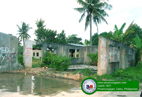 Cadre The abandoned ruins of the Cadre at Barangay Pandacan, which was used as an American Headquarters in 1937 and Stockage & Detention Cell during the Martial Law year
|